
2021 Atlantic Hurricane Season Shows No Signs of Letting Up
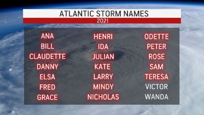
AccuWeather Global Weather Center – As Hurricane Sam continues to navigate across the Atlantic as a major hurricane, there are at least three other trouble spots that AccuWeather forecasters are monitoring for tropical development across the basin this week. Following the formation of Subtropical Storm Teresa on Friday, only two names remain on the list for the season — and both names may soon be used. It is only a matter of time before the season shifts to rank in third place for all-time number of named storms generated in one hurricane season.
 At times, the 2021 season has been neck and neck with the record-setting 2020 Atlantic hurricane season, which spawned 30 named storms. But, at this point, the season is trailing behind last year for the number of named storms to date. Last year, 23 named storms had already developed as of Sept. 24.
As of Monday, 2020 was in a five-way tie with the 1887, 1995, 2010, 2011 and 2012 seasons for fourth place in terms of the number of named tropical systems at 19. In order to outrank the third most active season on record, two additional tropical storms would need to develop this year. The 1933 season currently ranks in the no. three spot with a total of 20 named storms. The notorious 2005 hurricane season ranks in the no. two spot with a total of 28 named storms.
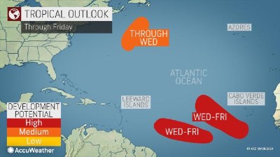
"There are three systems that have the potential to become tropical depressions and storms this week over the Atlantic basin," AccuWeather Hurricane Expert Dan Kottlowski said, adding that only two of these are likely to take on a new name from the 2021 list.
One of these candidates is located a few hundred miles east of the Atlantic coast of the United States. This system has about a 50-50 chance of coming back to life as a tropical depression or storm. "If it should reach tropical storm status, then it would likely retain the name Peter, since this is the old circulation center from the former tropical storm from earlier in September," Kottlowski explained.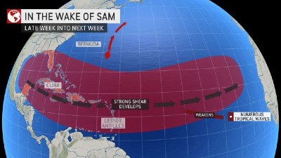
Late on Friday, Subtropical Storm Teresa formed from a small part of Peter's leftover moisture but not from the circulation center. "Because Teresa did not form from the center from a once-named tropical system, it was given a different name," Kottlowski said. Because Teresa contained both tropical and non-tropical features, it was dubbed a subtropical storm, even though the tropical portion of the system was rather slight.
Regardless of whether or not Peter makes a comeback, the system will not pose a threat to land. Even though Bermuda is a few hundred miles to the northwest, the system is likely to remain weak, and it should keep its distance from the islands.
Thousands of miles farther to the southeast of the potential "zombie" Peter system, and to the southeast of Hurricane Sam, there are two tropical waves that AccuWeather meteorologists are monitoring for further tropical development this week.
 Both of these features recently emerged off the coast of Africa as tropical waves do, and both are in an environment that favors the further strengthening of the systems in the next several days.
Waters in that region of the Atlantic Ocean are sufficiently warm (at or above 78 F) for tropical development, wind shear is currently low, and there is not a tremendous amount of dry air and dust in the vicinity, according to Kottlowski.
"Both systems have a high chance of becoming tropical depressions and storms later this week, and in this case, the next two names on the list for the 2021 season will be used," Kottlowski said.
If the systems strengthen enough to become named tropical storms, the National Hurricane Center will name them Victor and Wanda.
"However, since both systems are likely to enter a wall of wind shear as they move across the Atlantic starting around this weekend, the organization and strengthening process may not last very long," Kottlowski said.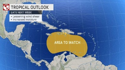
Because of the anticipated limiting effects of wind shear this weekend and beyond, the systems may not become high-end hurricanes, might not become hurricanes at all or might spend only a brief time as named systems.
The lead tropical wave (the disturbance nearest to the central Atlantic) is most likely to move the farthest to the west and could reach the Leeward Islands late this weekend or early next week, should it survive the belt of wind shear.
The trailing tropical wave (the disturbance closest to Africa) has a more significant chance of curving northwestward and northward over the central Atlantic, where it would be much less of a concern for any land areas. However, this storm may have a slight edge over the twin system farther to the west in that it is in a zone with the greatest amount of moisture available.
Meanwhile, Sam has been traveling through a zone favorable for a hurricane and may continue to do so even well past Bermuda this week. Sam has maintained hurricane status since the morning of Sept. 24.
Beyond the current features on the Atlantic map, AccuWeather meteorologists will be monitoring the Caribbean Sea for potential development toward the end of the first week of October.
Wind shear is expected to decrease over the Caribbean later next week and moisture is forecast to return to the region, according to AccuWeather Chief On-Air Meteorologist Bernie Rayno. "This area is perennially a trouble spot for tropical development as October progresses," Rayno said
Past hurricanes Michael, Sandy and Wilma are among the most recent systems to have developed over the Caribbean and caused loss of life and damage during October. The names of all three of those notorious storms have been retired.
Once the pre-selected list of names for the 2021 season has been exhausted after Wanda forms, the supplemental list prepared by the World Meteorologist Organization will be used to name systems. The list will replace the Greek alphabet, which was used to name storms amid two hyperactive seasons in the past: 2020 and 2005.