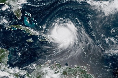
A Weakening Hurricane Erin to Pass Near Bahamas
MIAMI, FL – A weakening Hurricane Erin is expected to pass to the east of the southeastern Bahamas on Monday and move between Bermuda and the east coast of the United States by the middle of the week.
 An NOAA image of Hurricane Erin on Sunday morning.The Miami-based National Hurricane Center (NHC), however warned that the first hurricane of the 2025 Atlantic season will remain “a large and dangerous major hurricane” through the middle of this week.
In its latest weather bulletin the NHC said that Erin, a Category 4 hurricane is located about 105 miles north, north east of Grand Turk Island with maximum sustained winds of 130 miles per hour (mph).
The Bahamas government has since issued a Tropical Storm Watch for the central Bahamas and a Tropical Storm Warning is in effect for the Turks and Caicos Islands and Southeast Bahamas
Erin is moving towards the northwest near 13 mph and the NHC said a gradual turn to the north is expected later today and on Tuesday.
“On the forecast track, the core of Erin is expected to pass to the east of the southeastern Bahamas today and move between Bermuda and the east coast of the United States by the middle of the week.”
The hurricane has maximum sustained winds are near 130 mph with higher gusts.
“Erin is a category 4 hurricane on the Saffir-Simpson Hurricane Wind Scale. Some additional strengthening is expected today. Even though some weakening is forecast beginning tonight, Erin will remain a large and dangerous major hurricane through the middle of this week.”
The NHC said Erin is a large system and hurricane-force winds extend outward up to 80 miles from the center and tropical-storm-force winds extend outward up to 230 miles.
The outer bands of Erin will produce localized areas of heavy rainfall across portions of Hispaniola through today and through Tuesday for the Turks and Caicos and portions of the southeast and central Bahamas. Additional rainfall of two to four inches, with locally higher amounts to six inches, are forecast.
Swells generated by Erin will affect the Bahamas, Bermuda, the east coast of the United States, and Atlantic Canada during the next several days.
“These rough ocean conditions will likely cause life-threatening surf and rip currents, The NHC said, adding that “minor coastal flooding is possible in areas of onshore winds in the Turks and Caicos Islands and the southeast Bahamas.
“Near the coast, the surge will be accompanied by large waves,” it said.


